

Online tutorial
–> About
–> TESTUDO System Architecture
–> Robots
–> Sensors
–> AI for Data Processing
–> AI Decision Making
The TESTUDO Project
TESTUDO is a Horizon Europe-funded project that advances the protection of Critical Infrastructure through autonomous systems, AI, robotics, advanced telecommunications, and situational awareness technologies. The project delivers a highly mature platform for continuous monitoring, threat detection, prediction, and response in remote and challenging environments. By combining unmanned vehicles, secure interoperable networks, AI-driven surveillance, predictive intelligence, novel human-machine interfaces, and large-scale validation, TESTUDO aims to enhance the resilience, reliability, and security of European Critical Infrastructure while promoting the wider adoption of robotic technologies for infrastructure protection.
The TESTUDO System Architecture
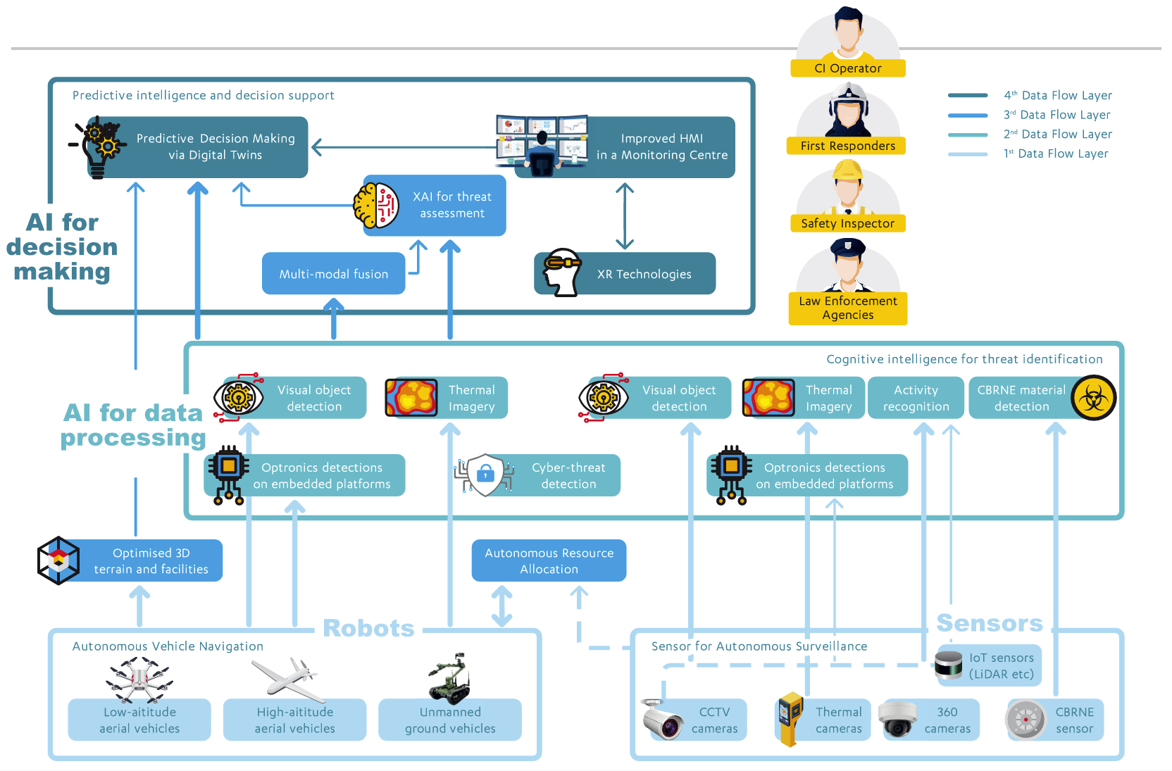
Robots
Kiiro and Yellow Unmanned Ground Vehicles
Surveillance and security patrols of large and remote critical infrastructure sites are challenging due to accessibility, coverage, and safety requirements. Prosegur addresses these challenges with two unmanned ground vehicles (UGVs): Yellow (Boston Dynamics SPOT) and Kiiro (Robotnik Summit XL), both equipped with cameras and sensors for autonomous patrol and inspection. Kiiro operates using local map-based navigation with or without GPS, while Yellow uses visual reference points for navigation in complex indoor environments. Integrated PTZ cameras and a unified security platform enable effective monitoring, improving operator safety, enhancing situational awareness, and supporting earlier threat detection and decision-making.
Coyote Unmanned Ground Vehicle
DFKI’s COYOTE unmanned ground vehicle (UGV) addresses CIP through a lightweight, highly mobile robotic platform that can carry up to 10 kg of sensors and payloads (such as TEKNIKER’s Embedded Vision system). Equipped with cameras, LiDAR, and an IMU, COYOTE supports autonomous navigation and environmental monitoring while also allowing remote-controlled operation. Its compact design enables rapid deployment by a single operator, making it suitable for inspecting potentially dangerous or inaccessible areas while improving safety, situational awareness, and operational efficiency.
CERBERUS Unmanned Aerial Vehicle
ACCELIGENCE’s CERBERUS unmanned aerial vehicle (UAV) is a multirotor platform which combines advanced sensing, onboard processing, and flexible deployment capabilities to support inspection, surveillance, and detection missions. Its modular design accommodates multiple payloads, including thermal, RGB, LiDAR, and CBRN sensors, enabling operation across diverse scenarios. CERBERUS provides real-time video and data transmission, onboard analytics, and reliable performance even in GNSS-denied environments. These capabilities improve situational awareness, support efficient monitoring of critical assets, enhance safety during inspections, and enable faster threat detection and response by security authorities.
Tethered Surveillance Platform
ADSCENSUS developed a tethered drone surveillance platform to overcome the limitations of traditional high-altitude surveillance systems, which are often expensive, complex, and infrastructure-intensive. The system provides continuous 24/7/365 operation through a ground-tethered power supply, enabling persistent situational awareness without downtime. Equipped with 4K imaging, 40× optical zoom, and a 360° rotating gimbal, it delivers high-quality surveillance and seamless target tracking. The platform supports secure fiber-optic data transmission, rapid deployment, operation in diverse environments, and compliance with emerging EASA regulations. Its minimal logistical footprint, payload flexibility, and uninterrupted monitoring capabilities benefit operators, infrastructure managers, and security authorities alike.
Sensors
LIDARs
The Ouster OS1 LiDAR, provided by PROSEGUR, addresses the limitations of conventional camera-based surveillance in poor weather and low-light conditions. Using pulsed-light technology, it generates point-cloud visualizations without capturing personal data, supporting privacy-preserving monitoring. Combined with AI-based analytics, the system can detect and classify vehicles, people, and objects within a defined area and automatically forward alerts to a control center. The technology enhances situational awareness in locations where cameras are ineffective or cannot be installed. Stakeholders benefit from improved detection capabilities, scalable deployment, earlier threat identification, and better-informed security and infrastructure management decisions.
Visual and Multispectral Cameras
The HW-10 Axis PTZ camera and HW-11 Hikvision multispectral camera, provided by PROSEGUR, address the need for enhanced visual monitoring of critical areas. The system combines live operator-controlled RGB imaging with multispectral sensing and advanced zoom capabilities to improve surveillance coverage and target observation. Both cameras can be integrated with AI-based detection modules, enabling automated threat identification and analysis. The solution enhances visibility and inspection capabilities for critical infrastructure operators, supports seamless integration with existing control centers for infrastructure managers, and provides security authorities with earlier threat detection, improved situational awareness, and more informed decision-making.
VER Airborne Chemical Detector
The DOVER sensor developed by T4i is a compact chemical detection system designed for real-time identification of airborne hazardous substances in dangerous environments, helping reduce risks to first responders. Optimized for both handheld use and UAV deployment, the lightweight 1.8 kg detector enables flexible operation in CBRN-E incidents. Key features include early threat detection, seamless data sharing, and an internal self-decontamination mechanism that reduces false positives and improves reliability. By providing rapid detection and identification of chemical threats from a safe distance, the system minimizes human exposure to toxic agents and supports proactive decision-making, enhancing the safety and effectiveness of emergency response operations.
AI for Data Processing
Autonomous Fleet Coordinator
A mission planning software framework has been developed by SINTEF to improve the surveillance and inspection of critical infrastructure using coordinated fleets of heterogeneous autonomous vehicles. The software dynamically plans, coordinates, and re-optimizes the trajectories of multiple UxVs in real time, enabling resilient operations in uncertain and changing environments. It continuously adapts to disruptions such as vehicle failures, communication loss, or environmental changes while maintaining efficient mission execution. By supporting scalable multi-vehicle operations, the system enhances coverage of large infrastructure areas. Stakeholders benefit from improved situational awareness, reduced inspection costs, faster anomaly detection, quicker incident response, and more efficient monitoring of critical assets through autonomous and coordinated surveillance operations.
3-D Reconstruction Tool
This tool developed by CERTH addresses the challenge of creating accurate 3D reconstructions of critical infrastructure assets for security and monitoring purposes. Using visual data captured by unmanned aerial vehicles (UAVs), the system automatically generates detailed geolocalized 3D models of infrastructure assets. The workflow combines COLMAP for sparse model reconstruction, NerfStudio/gs2mesh for mesh extraction, and Cesium Ion for geolocation and visualization. By transforming aerial imagery into precise digital representations, the solution enables enhanced situational awareness and asset inspection.
Visual Detection Tool
The VisDetect Tool developed by CERTH addresses the need for reliable real-time threat detection in critical infrastructure monitoring using heterogeneous robotic platforms such as UAVs and UGVs. The AI-based visual analytics module processes live video streams from CCTV cameras, drones, and ground robots to automatically detect and classify more than 30 object categories, including fire, smoke, people, and infrastructure-related objects. Operating at over 25 FPS with validated detection accuracy exceeding 80% mAP, it generates structured events and communicates them through Kafka-based interfaces for seamless system integration. The solution enhances situational awareness, enables earlier threat detection and faster response, reduces manual monitoring effort, and supports interoperability with existing robotic and command systems.
Multispectral (Thermal) Detection Tool
The MulDetect Tool developed by CERTH addresses the limitations of conventional visual monitoring by leveraging thermal imaging to provide reliable detection under low-light, foggy, rainy, and other challenging environmental conditions. The AI-based module processes live thermal video streams from UAVs, UGVs, and fixed cameras to detect and classify key objects, including fires, people, and vehicles, with high accuracy and processing speed. The system delivers annotated live video, image snapshots, and Kafka-based event notifications for seamless integration into existing monitoring platforms. Stakeholders benefit from robust all-weather performance, enhanced situational awareness, improved decision support, and reduced dependence on manual monitoring operations.
Embedded Visual Detection Tool
The AI-driven embedded detection module by TEKNIKER enhances continuous threat monitoring for critical infrastructure by processing visual data directly on-board UAVs and UGVs. Designed for deployment on embedded systems, it enables real-time object detection at up to 10 FPS without relying on external processing resources. The solution supports three AI models and six object classes, including injured people, vehicles, fire, and smoke, with validated detection accuracy above 70% mAP. Kafka-based event communication enables seamless integration with existing robotic and command systems. By providing proactive threat identification, improved situational awareness, faster response capabilities, and privacy-preserving local data processing, the system strengthens operational effectiveness in dynamic and complex environments.
Action Recognition Tool
The Action Recognition Tool by VICOM addresses the challenge of identifying potential threats in critical infrastructure environments by analyzing the actions of people and vehicles rather than relying solely on object detection. The AI-based solution processes live CCTV streams in real time, using temporal sequence analysis to recognize complex behaviors and security-relevant activities. It supports both vehicle-based and person-based action recognition, achieving high performance across multiple threat scenarios. By detecting anomalies as they occur, the tool enhances situational awareness and operational decision-making.
AI for Decision Making
Explainable AI (XAI) Model
Deep neural networks are often criticized as opaque “black-box” systems, creating security concerns and challenges for regulatory compliance. To address these limitations, VICOM developed a specialized Explainable Artificial Intelligence (XAI) pipeline that transforms neural activations into a hierarchical sequence of Behavior, Attribute, and Filtered graphs, enabling transparent and auditable analysis of model decisions. The implemented framework preserves topological consistency across graph representations, supports dynamic impact visualization, and applies threshold-based filtering to isolate critical decision pathways. By providing interpretable model insights, technical documentation, and visual evidence, the tool facilitates vulnerability assessment, risk mitigation, and compliance with emerging transparency, security, and governance requirements.
SAFER – AI & Complex Event Processing (CEP)
Critical Infrastructure operators often lack integrated capabilities to correlate cyber, physical, and environmental threats in real time, limiting effective decision-making. To address this challenge, an advanced secure-by-design situational awareness and decision-support framework was developed by ENGINEERING. The tool integrates cyber, physical, environmental, IoT, and OT data into a unified operational view and applies AI-driven analytics to detect anomalies, identify systemic risk propagation, and predict emerging threats. Its interoperable architecture supports integration with existing command-and-control systems while ensuring resilience and compliance. By enabling proactive risk anticipation, faster response, optimized resource allocation, and scalable deployment, the framework strengthens operational efficiency and infrastructure resilience.
Predictive Modelling
Early prediction of fire severity is essential for effective emergency response in critical infrastructure environments. To address this challenge, CERTH built the SW3-PredictionAnalysis module as a decision-support tool for first responder teams. The system processes real-time air-quality sensor data, including CO, PM, and CO₂ measurements, to predict short-term changes in fire severity levels and provide timely alerts. Designed for ease of deployment, the module enhances operational awareness by supporting continuous monitoring of rapidly evolving incidents. By delivering predictive insights and actionable information, the tool enables faster and more informed decision-making, improves situational awareness, and strengthens emergency response capabilities.
Extended Reality Tool
Protecting Critical Infrastructure (CI) requires operators to process large volumes of data, which can create information overload and hinder effective decision-making. To address this challenge, an XR-enabled Digital Twin solution was developed by Sheffield University that leverages the expansive workspace of eXtended Reality technologies for enhanced situational awareness. The platform supports advanced visualization of infrastructure assets through 3D models, Gaussian splats, and terrain maps, while providing customizable human-machine interfaces and intuitive interaction methods. Integration with automated surveillance and alert-management systems enables fused, prioritized operational insights. By reducing cognitive burden, the solution improves situational awareness, decision-making, and the effectiveness of critical infrastructure protection.
TESTUDO Monitoring Center
Critical Infrastructures (CI) face increasingly complex threats, including cyber-physical attacks, natural hazards, and safety incidents, requiring enhanced resilience and response capabilities. To address these challenges, the TESTUDO Monitoring Centre was developed by SATWAYS Ltd.as an advanced command-and-control (C2) platform that integrates data from diverse sensors and services into a unified operational environment. The system supports the complete incident lifecycle, including monitoring, detection, prediction, preparedness, real-time incident management, and post-event learning. By combining multimodal data fusion, AI-driven threat detection and prediction, Digital Twin models, and extended reality functionalities, the platform enhances situational awareness, enables earlier threat detection, improves response effectiveness, and optimizes resource allocation across critical infrastructure operations.
NEON – Software-defined Swarm Network
Robotic operations in large critical infrastructures are constrained by limited network coverage, hard-to-reach environments, vulnerability to single points of failure, and the high cost of dedicated 5G or Wi-Fi deployments. NEON, a dynamic networking solution, was developed that leverages reconfigurable and cost-effective network interfaces to adapt communication paths in real time. The system supports traffic rerouting through nearby mobile or fixed nodes, swarm-aware network reconfiguration, and pre-emptive adaptation to link degradation. With lightweight control overhead and per-flow routing optimization, the solution enhances communication reliability, prioritizes critical data streams, and provides a resilient network architecture without single points of failure.